Live Tides
NOTICES TO MARINERS
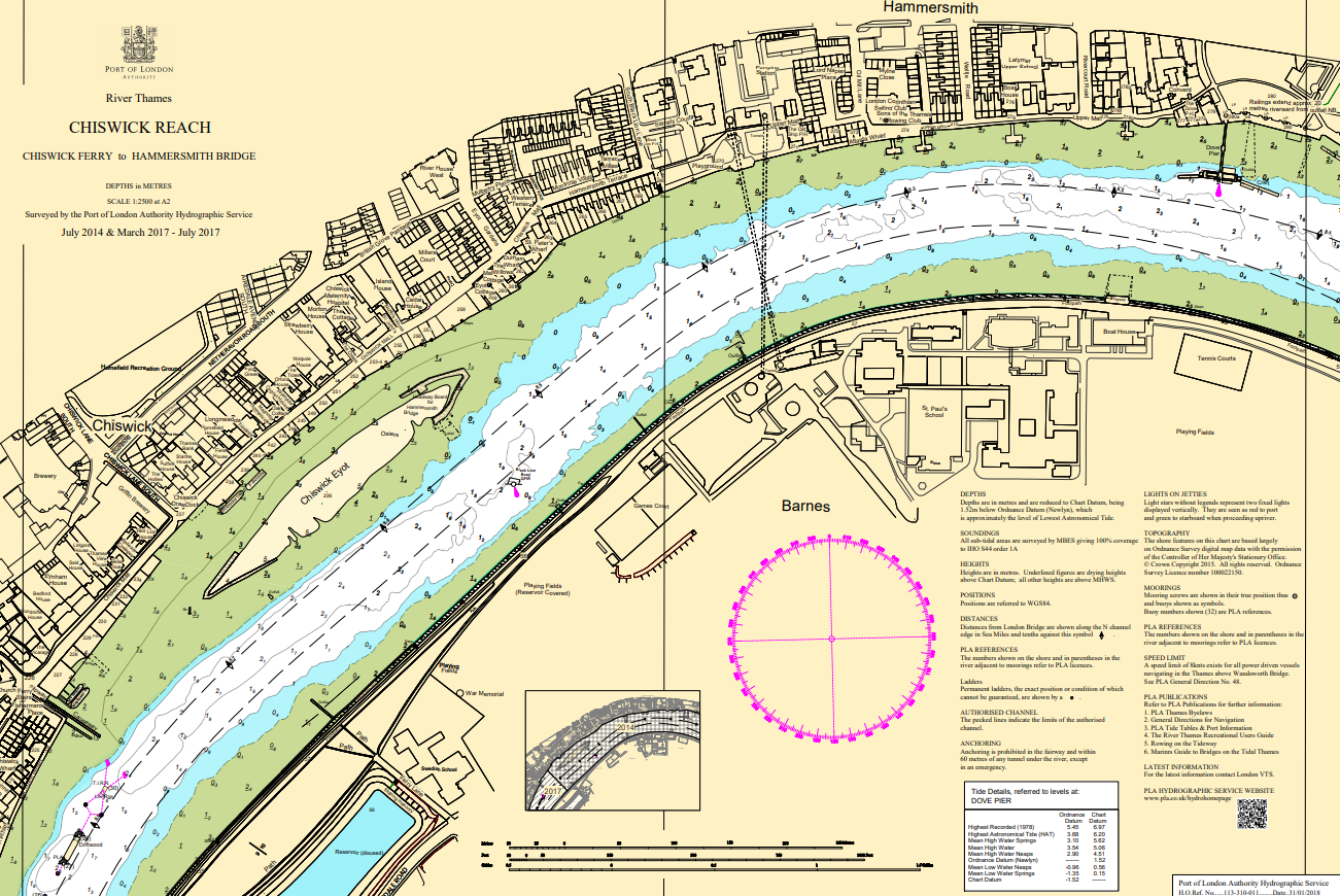
Charts & Surveys
Incident reporting
Life-threatening emergencies on the river:
Call 999 and ask for the Coastguard
For near miss, safety observations and incident reporting click below
Poster: Ecology of the tidal Thames
The river is home to a huge variety of plants and animals, some of which are protected within its multiple conservation areas
You'll be amazed what pops up in the Thames
The Zoological Society of London is collecting data on the dolphins, porpoises, and seals that visit the Thames to help develop our understanding of how these beautiful creatures use our estuary
Gallions Lower Tidal Test Site – Environmental Description
Port of London Authority Maintenance Dredging Framework Update 2022
Climate change on the tidal Thames (2021)
Impacts, adaptation and mitigation
Technical requirements for the issue of a Certificate of Compliance (Thames Byelaw 16)
Light Freight: Design Solutions for Thames Freight Infrastructure
Cross River Partnership (CRP), a non-profit and impartial partnership organisation, is excited to announce the launch of new report ‘Light Freight: Design Solutions for Thames Freight Infrastructure’.
There is an increased interest and desire to use the tidal River Thames to transport light freight, alongside the heavier freight already transported on the river to secure potential environment and logistical benefits. Light freight services on the Thames could potentially benefit numerous consumers and be a financially viable method of reducing road vehicle movements in central London. The services would contribute towards the Mayor of London’s Plan Transport Strategy and the River Action Plan.
As part of the DEFRA-funded Clean Air Villages 4 project, Cross River Partnership and the Port of London Authority (PLA) have commissioned Beckett Rankine to investigate the feasibility of handling light freight at London piers. This study provides costing and guidelines on pier adaptation that would be required for different pier structures and operational handling approaches to provide robust and agile solutions.
The report has been undertaken in association with the Thames Estuary Growth Board (TEGB), and the study builds on a recent report published by the TEGB and the PLA.
This study contributes toward the PLA and Government objective of achieving net zero carbon emissions by 2050 as set out in PAS 2080. The study considers two models for a successful light freight service: partial service and continuous service. These represent different visions for how the service could operate and face different challenges in how they could be incorporated on the tidal Thames.
A finalised shortlist of seven pier locations is included in this study:
- Wandsworth Riverside Quarter Pier
- Chelsea Harbour Pier
- Battersea Power Station Pier
- Blackfriars Pier
- Bankside Pier
- Tower Bridge Quay
- Masthouse Terrace Pier
A suite of design solutions demonstrate how each of the shortlisted pier locations could be incorporated into the light freight service to service either a partial or a continuous service. The cost of this design solution has been provided for each pier to demonstrate the potential costs involved.
This study confirms the intended focus of the light freight service which is to be smaller, more manoeuvrable cargo, such as letters and parcels, medical supplies, food and drink, and other business supplies. This cargo is to be moved primarily with a roll on-roll off approach, although the ability to manhandle goods is to be allowed for, where possible.
Fiona Coull, CRP Project Manager, said: “Within the context of an increased desire to use the tidal Thames to transport light freight, CRP is pleased to publish a study into investigating the feasibility of handling light freight across London’s piers. We hope that this study will contribute to an expanded, sustainable use of the Thames and a better environment for all Londoners.”
James Trimmer, the PLA’s Director of Planning and Development, said: “Changed shopping habits resulting from the pandemic present a major opportunity to grow the transportation of more light freight on the Thames in London. Modifications to the river’s existing infrastructure to facilitate more deliveries by boat, have the potential to transform the Thames into a green highway for parcels. In the process, they are set to play a key role in helping meet Net Zero targets in the capital, cutting road congestion and carbon emissions.”
For more information on the Clean Air Villages 4 programme, please contact CRP Project Manager Kate Fenton, [email protected]