Live Tides
NOTICES TO MARINERS
Charts & Surveys
Incident reporting
Life-threatening emergencies on the river:
Call 999 and ask for the Coastguard
For near miss, safety observations and incident reporting click below
The Port of London Authority commissioned Oxford Economics to produce forecasts of cargo handled in the Port of London to the year 2050 and identify opportunities and challenges for the PLA and stakeholders.
Explore the Thames Vision 2050
The Thames Vision is built around three interconnected themes, centred on the role the river plays for people and the environment.
The No. 1 Net Zero UK commercial hub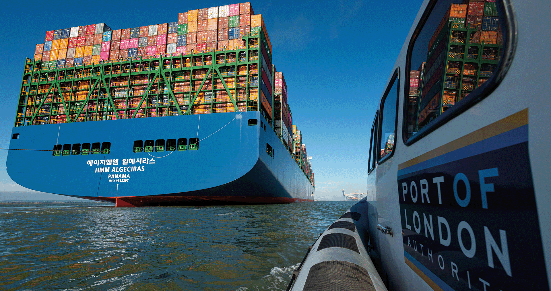
The country’s largest and most competitive port, closest to the UK’s biggest market, producing Net Zero emissions. Improved connectivity to road and rail infrastructure. Technologically innovative, expanding the transportation of light freight into central London as urban logistics transform.
A place to live, visit, play and enjoy
Accessible to all, a national and international icon for the city and the country. More visitors, drawn to the river as the best way to enjoy London and the Thames Estuary, and its many cultural attractions. More people from diverse backgrounds enjoying sport and leisure opportunities on the Thames.
Clear air, water and land
A clean river, free of sewage, waste and other pollution, supporting greater biodiversity and recreational use. Valued for its clean air, natural flood defence, wildlife and as a carbon sink.
The Port of London Authority appointed SQW in February 2020 to estimate the direct and indirect economic impact of port activities across defined geographic areas and identify trends. This provides an update on progress in the delivery of the Thames Vision 2035, our collaborative plan for sustainable growth in use of the Thames, which was launched in 2015 alongside a similar study. The study estimates a total direct and indirect impact of around 48,000 FTEs and a GVA contribution of £4.5bn, offering a snapshot of activity just prior to the onset and economic effects of the Covid-19 pandemic in the UK. It provides a focus for our efforts with stakeholders, to be reflected in a refreshed Thames Vision, to sustain this activity as part of the economic recovery and move beyond it to a sustainable future.
The Port of London is one of the largest ports in the UK, handling 54 million tonnes of freight in 2019 and growing 20% over the past five years compared to an overall 3% fall in the freight tonnage handled by all UK major ports. Reflecting its status as a major port, London deals with freight traffic from around the world, with EU freight traffic particularly prominent. In addition, there are also significant volumes of passengers who use the Thames, with around 10 million journeys made per year.
This study estimates that the London port sector directly employs almost 31,500 FTEs and generates a direct GVA of around £3.2bn. When wider impacts, such as supply chain activity and the spending of wages, are included it is estimated that around 48,000 FTEs and £4.5bn of GVA are dependent on the London port sector. These figures demonstrate the scale of the port sector and the important role it plays in the economies of London, Essex and Kent. The total employment and GVA impacts of the port sector are presented in the table below.
The port sector includes a variety of occupations. Overall, roughly half of all roles are office based, although this disguises significant variation between port sector businesses. In general, the workforce is less diverse than the area average, although again this varies by category of business. Some respondents commented on the difficulty in recruiting individuals with specific skills and were also concerned about an ageing workforce.
Looking forwards, a third of the businesses surveyed had a formal plan to reach net zero emissions. Businesses identified the lack of suitable technology and the cost of switching to more carbon efficient technologies as the two major barriers to reaching net zero emissions.
Port sector businesses interviewed were generally optimistic about the future, with 72% anticipating growth over the next five years and almost £950m of investment planned over this period.
Covid-19 poses a significant risk to this investment and the broader health of port sector businesses. The short-term reaction to Covid-19 will be important in shaping the future of the Port of London, as will medium and long-term responses to decarbonisation and the post-Brexit trading relationship with the EU.
Explore the Thames Vision 2050
The Thames Vision is built around three interconnected themes, centred on the role the river plays for people and the environment.
The No. 1 Net Zero UK commercial hub
The country’s largest and most competitive port, closest to the UK’s biggest market, producing Net Zero emissions. Improved connectivity to road and rail infrastructure. Technologically innovative, expanding the transportation of light freight into central London as urban logistics transform.
A place to live, visit, play and enjoy
Accessible to all, a national and international icon for the city and the country. More visitors, drawn to the river as the best way to enjoy London and the Thames Estuary, and its many cultural attractions. More people from diverse backgrounds enjoying sport and leisure opportunities on the Thames.
Clear air, water and land
A clean river, free of sewage, waste and other pollution, supporting greater biodiversity and recreational use. Valued for its clean air, natural flood defence, wildlife and as a carbon sink.
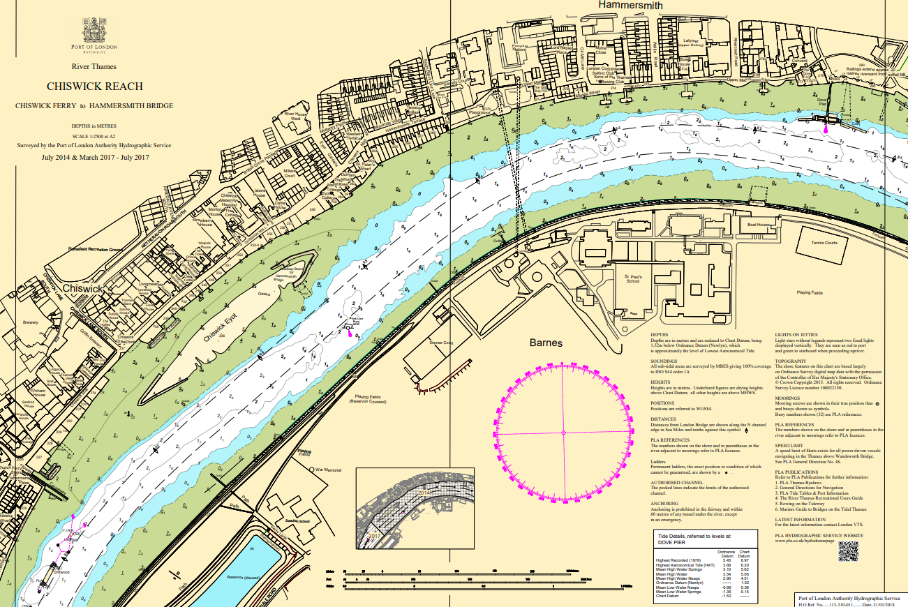
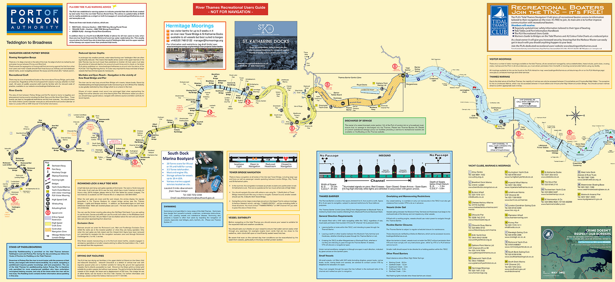
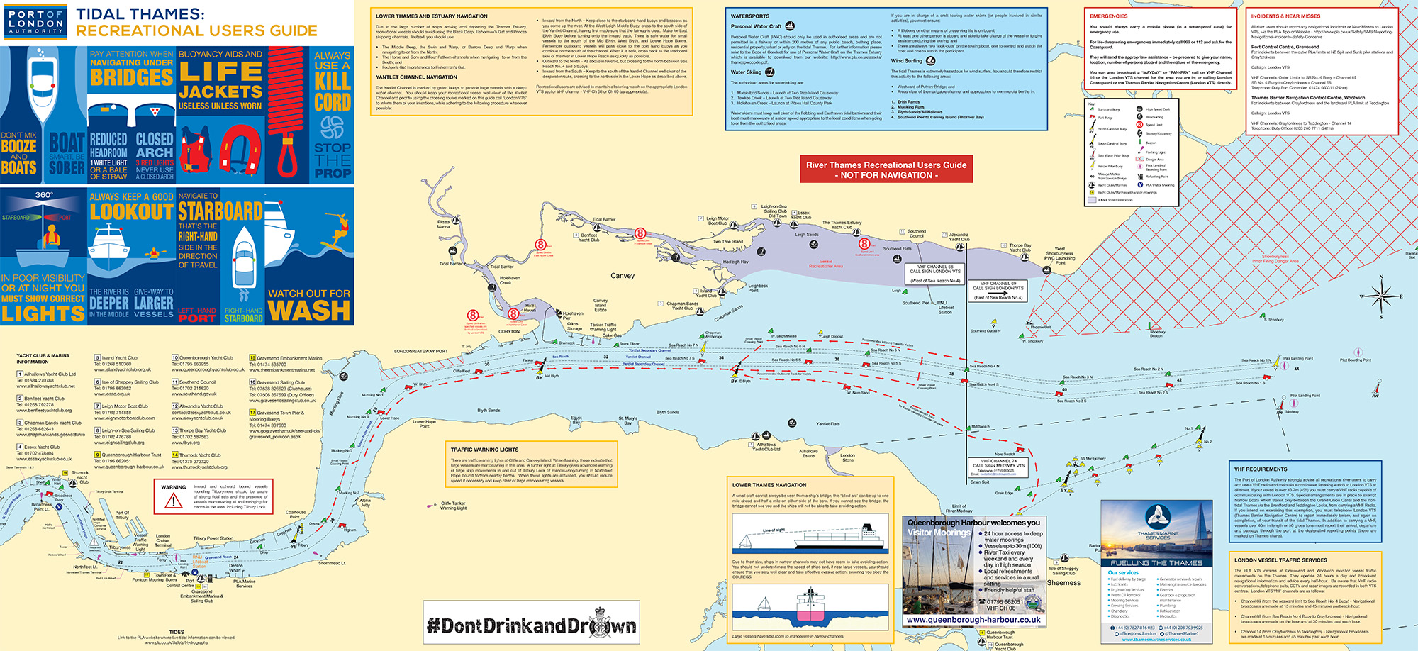
Recreational Users Guide
This easy-to-use guide is a two-sided map of the River Thames highlighting key points of interest and regulations for leisure users.
Pilot stations, boarding and landing areas
Commercial diving
Diving contractors intending to undertake any diving activity in the Tidal Thames must first obtain permission of the appropriate Harbour Master
To obtain permission, the diving supervisor is required to fill in and submit the diving permit to work form, together with copies of documents stated in the checklist.
The permit requires at least 2 working days.
Send the form and relevant documents to the Harbour Master:
Harbour Master (office hours, Monday to Friday 09:00 – 17:00)
[email protected]
01474 562 200
For urgent out of hours diving operations, contact London VTS
Tips on required documents
Submitted documents must be current. There is no need to resubmit previous documents that remain current, unless requested.
Project plan – should include, but is not limited to:
- Location, date and time of planned works
- Diving team members’ names
- Risk assessment, covering the task to be undertaken
- Emergency procedure
- Certificates of Competence must be approved by the Health and Safety Executive. Other Certificates, i.e. issued by BSAC (British Sub Aqua Club) or PADI (Professional Association of Diving Instructors) are not acceptable.
Cookies policy
The Port of London Authority respects your privacy and is committed to protecting your personal data.
Our privacy policy will inform you as to how we look after your personal data and tell you about your privacy rights and how the law protects you. The Port of London Authority abides by the requirements of the Data Protection Act 2018 and General Data Protection Regulations.
This web site uses "Google Analytics" for the collection of anonymous statistical information about users of the site.
Telephone calls, VHF radio traffic and CCTV/radar images may be recorded in the Vessel Traffic Service Centres at Gravesend and Woolwich.
Our full privacy notice is available at this link.
'Cookies'
We make use of cookies to gather valuable information about how users move around the site. This enables us to understand how the site is used and to make improvements. The information we gather by use of cookies does not include personally identifying information.
Three of the cookies we use are essential for parts of the site to operate and will have already been set. You may delete and block all cookies from this site, but please note that parts of the site may not work.
Essential site cookies:
- CFGLOBALS
- CFTOKEN
- CFID
These cookies are essential to maintain your session throughout your visit to this site.
Google Analytics:
- _utma
- _utmb
- _utmc
- _utmz
These cookies are used to collect information about how visitors use our site. We use the information to compile reports and to help us improve the site. The cookies collect information in an anonymous form, including the number of visitors to the site, where visitors have come to the site from and the pages they visited.
Click here for an overview of privacy at Google.
Most web browsers allow some control of most cookies through the browser settings. To find out more about cookies, including how to see what cookies have been set and how to manage and delete them, visit www.allaboutcookies.org.
Privacy policy
Our privacy policy will inform you as to how we look after your personal data and tell you about your privacy rights and how the law protects you.
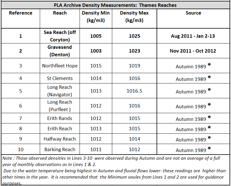
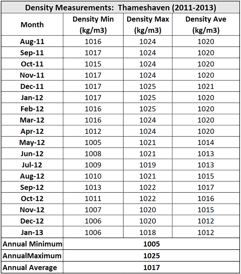
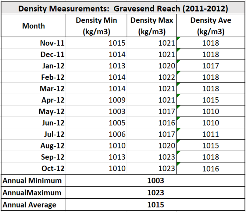
Water density readings
The tables below show observed water density readings held by the Port of London Authority (PLA) and are provided to serve as a guide only for water densities that may be encountered on the Thames.
The PLA accepts no responsibility as to their accuracy.
Density measurements vary temporally throughout the day and year and are significantly affected by local variations in salinity and temperature.
It is recommended that for density values to be used for draft or freshwater allowance calculations, that in situ measurements taken at the location of the vessel or terminal.
Thames bridge heights
Thames Bridge Clearances
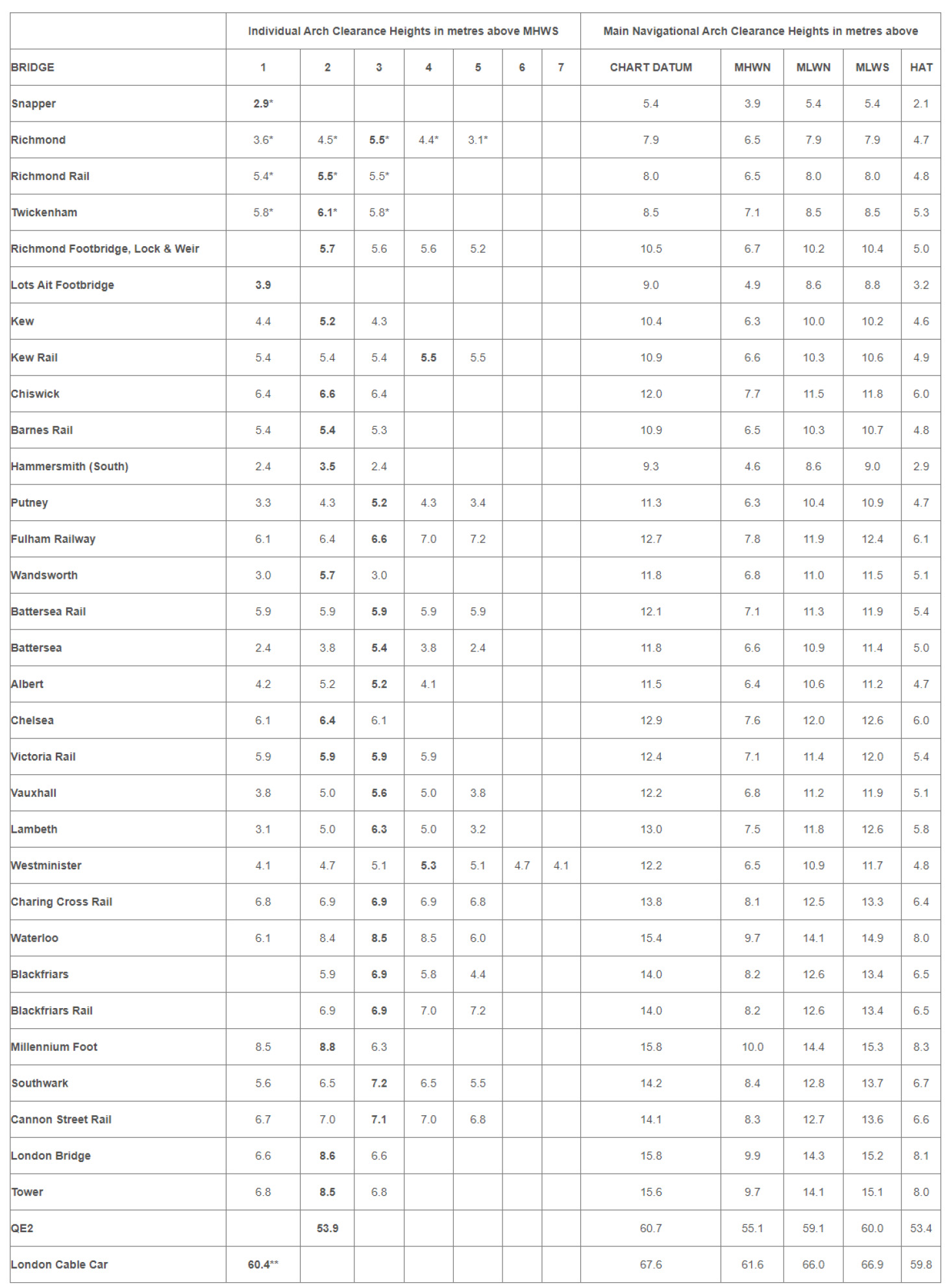
Clearance Heights identified in BOLD refer to the main navigational arch.
* Refers to headway above maintained water level.
** Refers to minimum clearance to bottom of cable car gondolas, when loaded and at the bottom of the catenary.
Arches are numbered from the north shore to south shore.
Further information on all the bridges can be found in the PLA "Mariners' Guide to Bridges on the Tidal Thames".
Headway Boards
Headway boards are provided at Hammersmith. Click here for details.
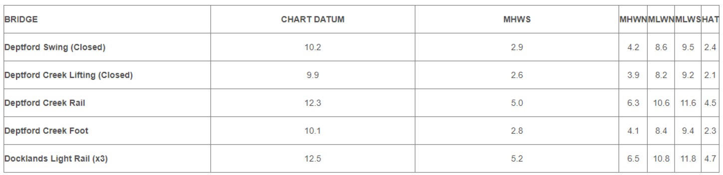
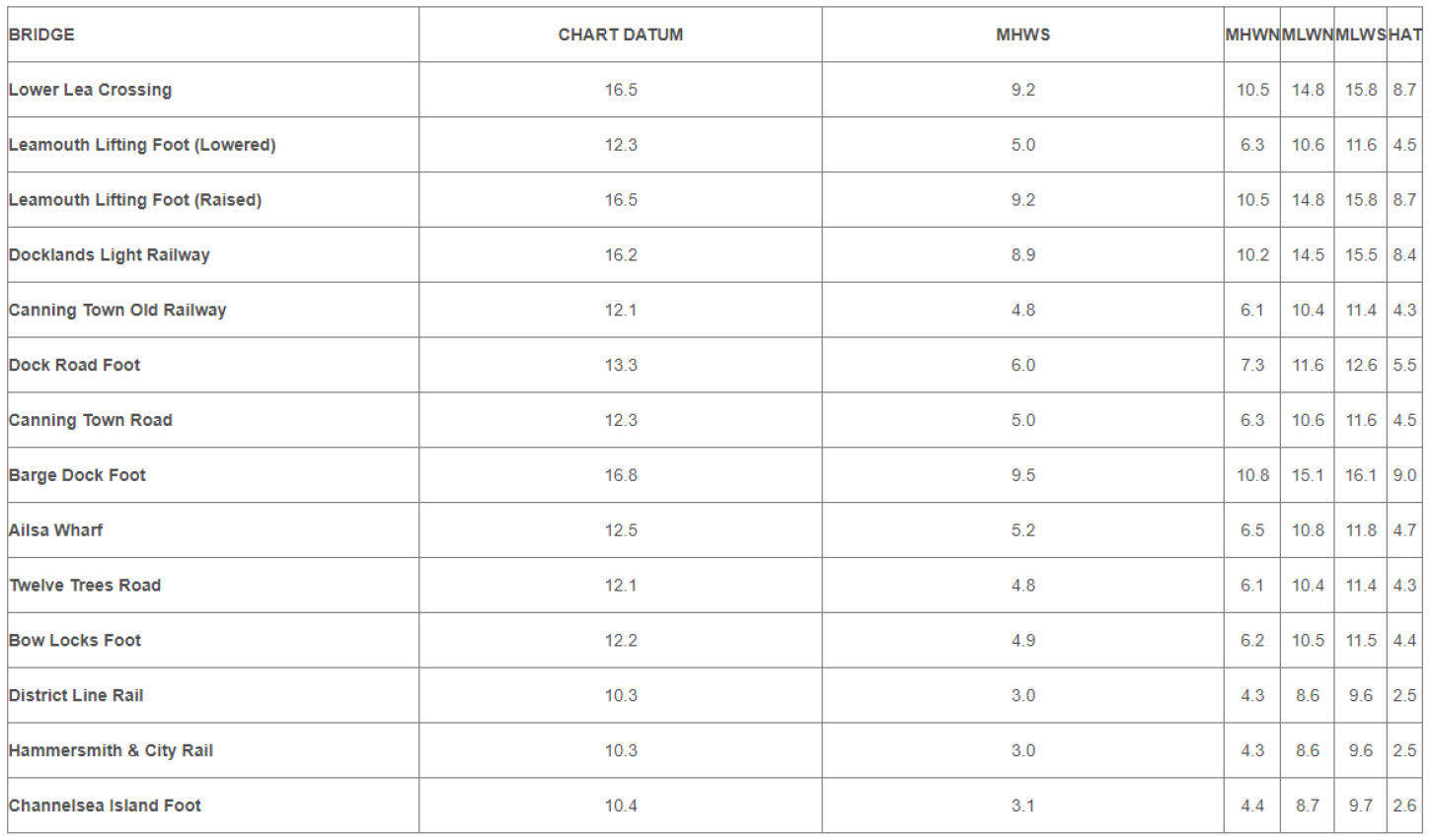
Bow Creek Bridge Clearances
Minimum Headway of NAVIGABLE ARCH in METRES above:
Deptford Creek Bridges Clearances
Minimum Headway of NAVIGABLE ARCH in METRES above: