Live Tides
NOTICES TO MARINERS
Charts & Surveys
Incident reporting
Life-threatening emergencies on the river:
Call 999 and ask for the Coastguard
For near miss, safety observations and incident reporting click below
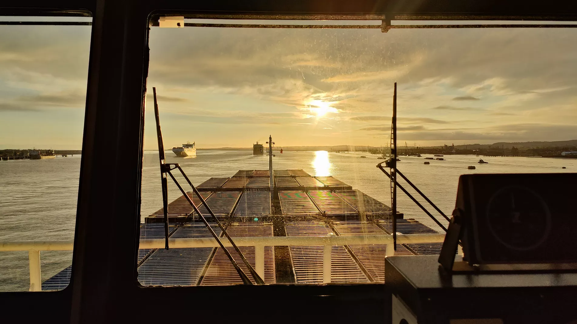
Tidal information
From live tides to predicted lows, we have tools to assist with your project
 Live tides
The Erith tidal gauge is currently offline. To estimate the tide times at Erith, find the midpoint between the tides at Silvertown and Tilbury gauges.
Live Tides for
Tide Overview
Turning Point
Tide Tables and Port Information 2025
Download now
Mariners' information
From critical depths to tide forecasting, these resources and tools will ease preparation for passage on the tidal Thames.
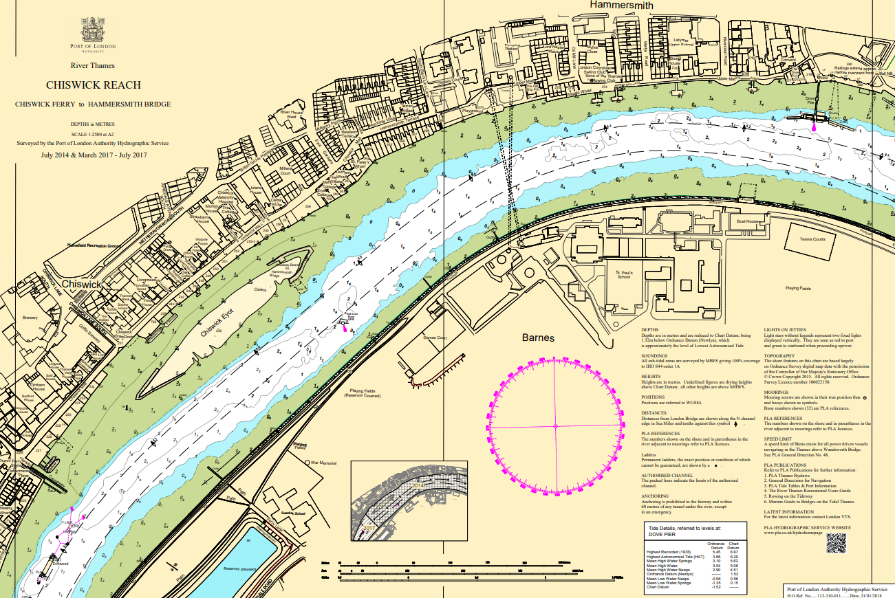
Latest editions and corrections of our navigational charts are available from our GIS system.
From live tides to predicted lows, we have the tools to assist with your project.
Up to date depth information for points along the tidal Thames.
Tide reductions and tidal stations on the tidal and estuary Thames.
The latest depths for public ship tiers and moorings.
Bridge clearances on the tidal Thames, Bow Creek and Deptford Creek.
Observed water density readings that may be encountered on the Thames.
PLA services and navigation guidance as easy as A, B, C.
Find a distributor of ADMIRALTY Digital Charts.
Tides - definitions and notes
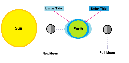
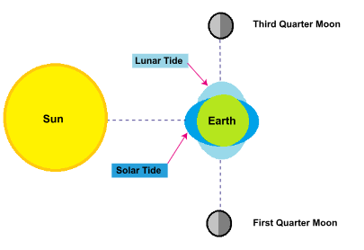
The gravitational forces of the moon and sun create areas of high and low water on the earth's surface. As the earth rotates the location of high and low tide changes. The moon has the greatest effect on the water compared with the sun due to its proximity to the earth and the configuration of the sun and moon, whether aligned or offset, has an effect on the tidal range.
The tides of increased range occurring near the times of full moon and new moon. The gravitational forces of the moon and the sun act to reinforce each other. Since the combined tidal force is increased the high tides are higher and the low tides are lower than average. Spring tides is a term which implies a welling up of the water and bears no relationship to the season of the year.
The tides of decreased range occurring near the times of first and third quarter phases of the moon. The gravitational forces of the moon and the sun counteract each other. Since the combined tidal force is decreased the high tides are lower and the low tides are higher than average. Neap comes from a Greek word meaning scanty.
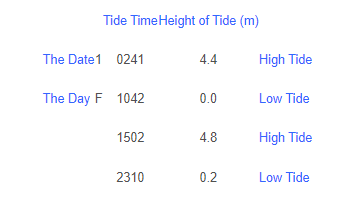
Tide tables give the high and low water times and heights for particular locations as shown by the example table below. All times are given in Greenwich Mean Time so please remember to add an hour during British Summer Time. All heights are in metres above local chart datum.
The tidal levels are defined below. For the table of chart datums and standard levels in the Port of London, please click here. For an introduction to chart datums and charting on the Thames please click here.
HAT (Highest Astronomical Tide) & LAT (Lowest Astronomical Tide)
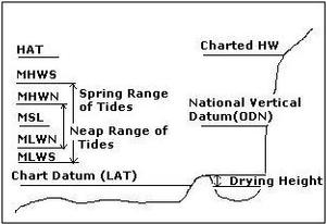
The highest and lowest levels respectively which can be predicted to occur under average meteorological conditions and under any combination of astronomical conditions; these levels will not be reached every year. HAT and LAT are not the extreme levels which can be reached as storm surges may cause considerably higher and lower levels to occur.
MHWS (Mean High Water Springs) & MLWS (Mean Low Water Springs)
The height of mean high water springs is the average of the heights of two successive high waters during those periods of 24 hrs (approximately once a fortnight) when the range of the tide is greatest. The height of mean low water springs is the average height obtained by the two successive low waters during the same period, i.e. -
MHWS The average HEIGHT of the HIGH WATERS of SPRING TIDES above Chart Datum.
MLWS The average HEIGHT of all LOW WATERS of SPRING TIDES above Chart Datum.
MHWN (Mean High Water Neaps) & MLWN (Mean Low Water Neaps)
The height of mean high water neaps is the average, throughout a year as defined above, of the heights of two successive high waters during those periods (approximately once a fortnight) when the range of the tide is least. The height of mean low water neaps is the average height obtained from the two successive low waters during the same periods, i.e.
MHWN The average HEIGHT of the HIGH WATERS of NEAP TIDES above Chart Datum.
MLWN The average HEIGHT of the LOW WATERS of NEAP TIDES above Chart Datum.
The values of MHWS, MHWN, MLWN and MLWS vary from year to year in a cycle of approximately 18.6 years. In general the levels are computed from at least a year’s predictions and are adjusted for the long period variations to give values which are the average over the whole cycle. The values of Lowest Astronomical Tide (LAT) and Highest Astronomical Tide (HAT) are determined by inspection over a span of years.
MHW (Mean High Water) & MLW (Mean Low Water)
The height of mean high water is the average height between mean high water springs and mean high water neaps as defined above. The height of mean low water is the average height between mean low water springs and mean low water neaps. i.e.
MHW The average HEIGHT of the HIGH WATERS of SPRING and NEAP TIDES above Chart Datum.
MLW The average HEIGHT of the LOW WATERS of SPRING and NEAP TIDES above Chart Datum.
MSL (Mean Sea Level)
Mean Sea Level is the average level of the sea surface over a long period, normally 19 years, or the average level which would exist in the absence of tides, i.e.
The average HEIGHT of the surface of the SEA at a TIDE STATION for all stages of the TIDE over a 19 year period, usually determined from hourly height readings measured from a fixed predetermined reference level (Chart Datum).
Depths in the Thames throughout the Port of London are measured to chart datum, which is defined as a level so low that the tide will not frequently fall below it. This level approximates to Lowest Astronomical Tide (L.A.T.) which is the lowest level that can be predicted to occur under average meteorological conditions and under any combination of astronomical conditions.

Chart Datum is also the level to which tidal levels and predictions are measured and is the same as the zero of the tidal predictions.
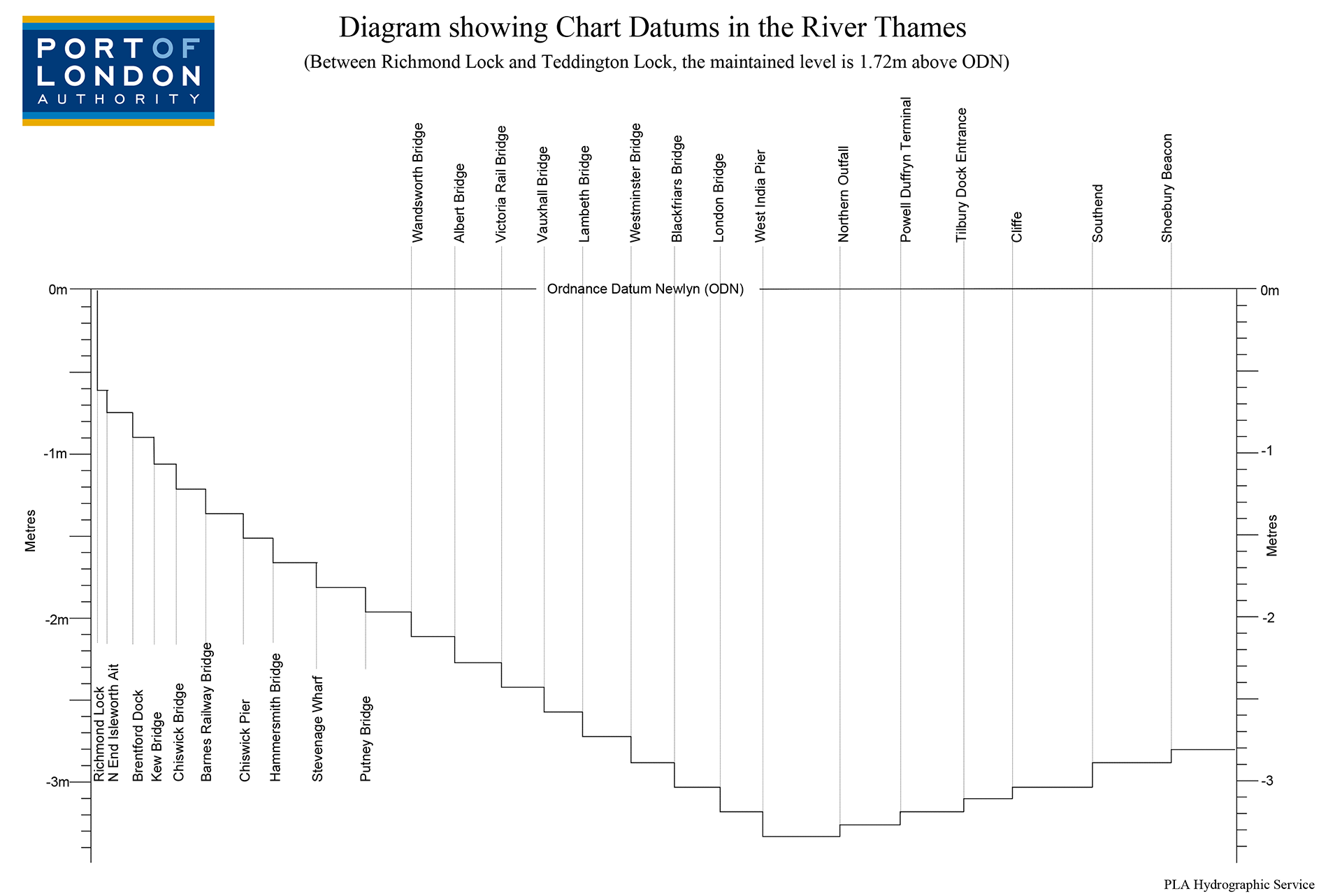
Connection between Chart Datum and Land Survey Datum
In the River Thames we use a step datum as the slope of the river makes it difficult to use L.A.T. - i.e. the gradient along the river is changing rapidly and therefore we assign a specific chart datum value for small sections along the river. These steps are spread out and the difference between each is fairly small, usually 10-15 cm, and are on average 2-2.5km apart.
The chart datum steps on the Thames are referenced to the UK vertical land datum called ODN (Ordnance Datum Newlyn). This refers all chart datum levels to a common, national horizontal plane and allows the levels to be checked. Such datums are referenced to fixed points called bench marks. The Ordnance Survey (OS) is Britain’s National Mapping Agency and maintains the national vertical datum.
A chart datum value is dependant upon the range of the tide at a particular location. It varies from place to place and therefore is not a suitable national reference plane.
PLA Charts show depths in metres and decimetres, all tidal heights and depths are in metric units. All depths on a chart are measured below chart datum. If the tide level were to fall to chart datum, i.e. zero, then the depth shown on the chart would be the actual depth at that time in the river. Likewise, if you know the charted depth at a particular location and you know the actual, real-time tide level then you will know the total depth of water at that time, i.e. charted depth + tide level = total depth.
Negative depths or underlined depths (23 ) are depths above chart datum (also known as drying heights) and represent the area on each side of the river - the beaches or mud-flats - or a drying bank in the estuary that will be exposed or dry-out at low water.
River surveys from Teddington to Woolwich and Estuary surveys are based on UTM Zone 31 and also show a WGS84 geographic graticule (latitude and longitude). River surveys from Woolwich to Sea Reach No 1 are based on the Ordnance Survey of Great Britain, with a National Grid graticule shown on most surveys.
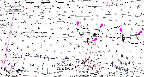
The Published Charts are compiled from the surveys of Rivers and Creeks. As new information is gathered they may be corrected by Chart Correction Advices. These are serially numbered for each Chart.
Topography is based on Mastermap data supplied by the Ordnance Survey. This information is amended at 3 monthly intervals by OS and verified by PLA when the surveys are taken in hand, but the data remains Crown Copyright.
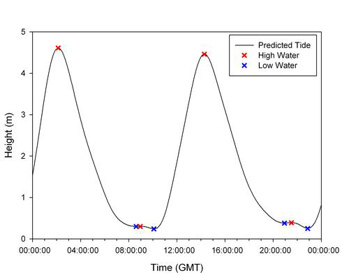
This phenomenon is not an error but due to the prolonged low water period that exists at Richmond. The prediction programme looks for the turning points in the tidal cycle (i.e. where the tide changes from rising to falling). At Richmond this means that slight variations in the prediction can result in consecutive low waters. The adjacent graph helps to explain this. The multiple low waters have not been edited out of the tide tables so as to illustrate the low water stand that occurs.
There can be slight differences in the order of a few minutes for predicted times or up to 0.1m for predicted heights between the values printed in the "Tide Tables and Port Information" booklet and those published on the PLA website.
These differences are due to the prediction software that produces them. The printed tide tables, hourly heights and predictions used in the Port Control Centres are generated by the Admiralty using their prediction software where as the web based predictions are generated in house by the PLA using Geotide to give predictions for up to 5 years in advance and for all tide stations. If these slight differences are critical to your passage plan, live tidal observations are broadcast on the port VHF channels and are available on our website.
For more information on tidal theory and commonly asked questions about tides, please visit the National Oceanography Centre website
Thames Vision 2050
We will create the UK’s leading port, central to the nation’s economy, with Net Zero emissions
A clean river, free of pollution and rubbish, supporting more sport, passengers and freight. A resilient Estuary, adapting to climate change and richer in wildlife. A more diverse Thames, providing jobs, learning and enjoyment to the whole community, and always, everyone, staying safe.