Live Tides
NOTICES TO MARINERS
Charts & Surveys
Incident reporting
Life-threatening emergencies on the river:
Call 999 and ask for the Coastguard
For near miss, safety observations and incident reporting click below
Charts & surveys
Our GIS platform provides mariners with the most current navigation charts, surveys and corrections, essential for safe maritime operations in the Port of London
On this page
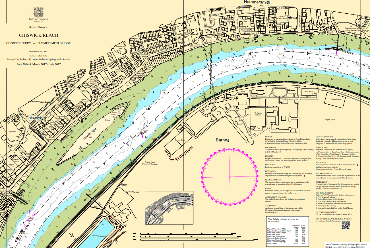
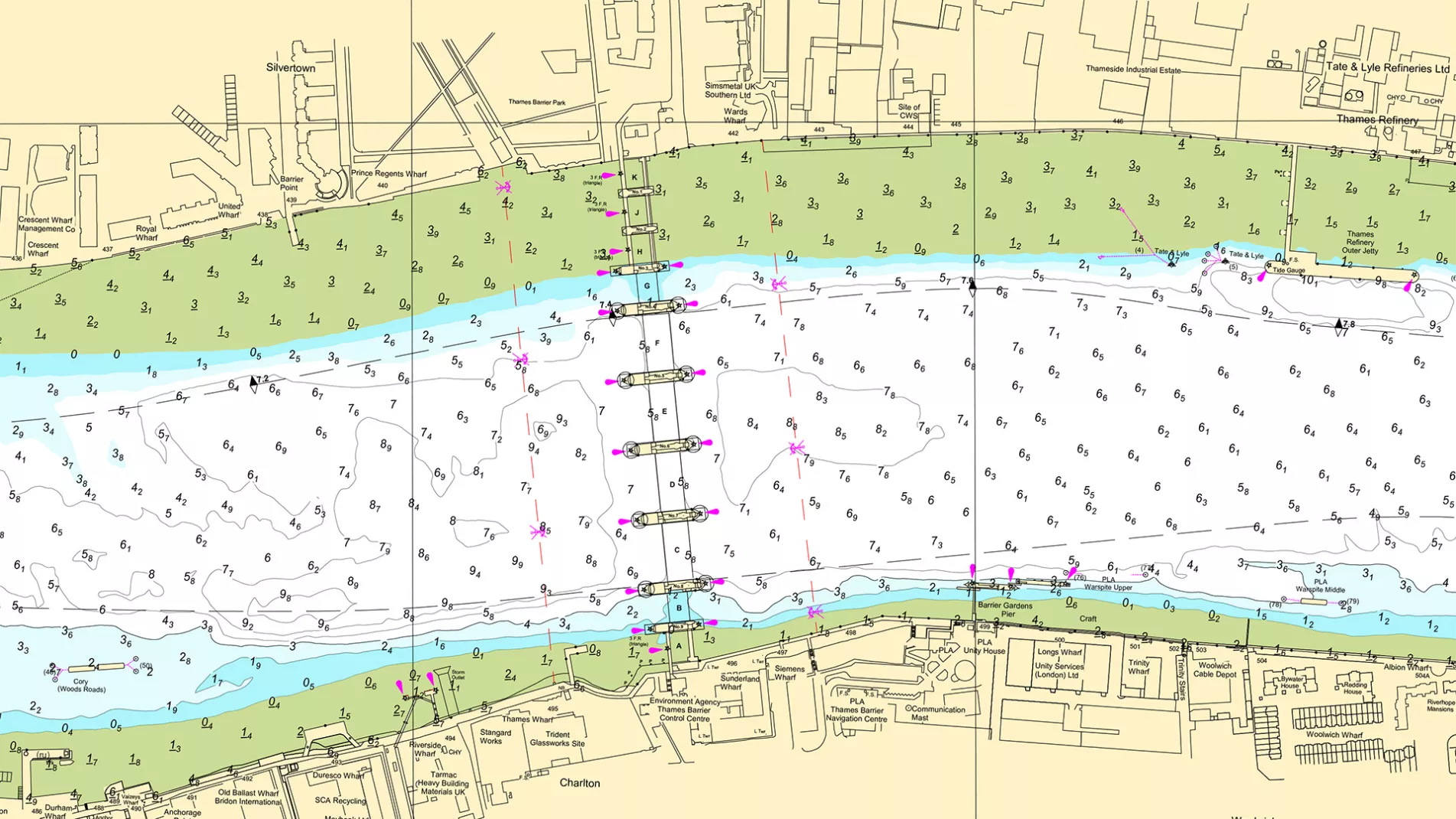
 Charts
Charts are periodically updated for navigationally significant changes as new survey data is captured and are the largest scale charts available.
Our GIS-based interactive map and table detail the charts (river main surveys) published by our Hydrographic team of the River Thames from Teddington to Southend.
We also produce smaller scale skeleton Miniplots depicting the latest significant soundings and contours from routine surveys which are intended to compliment, not replace, published nautical charts.
Printed copies of individual charts and folio sets are available to buy direct from the PLA shop.
Smaller scale Admiralty Charts produced by the UK Hydrographic Office are also available downstream of Tower Bridge and include port approaches in the Thames Estuary and may be a more appropriate scale for some users.
Mariners should ensure nautical publications and charts are always kept up to date with corrections. For PLA chart products, see the chart corrections advices (CCA’s) in the table below the map or for Admiralty products see Admiralty Notices to Mariners (NMs).
Geo-referenced images of the charts are provided for planning use in the central London area and further information on their use can be found at the bottom of the page.
Click on the relevant chart boundary in the map or via the table below for links to the charts.
A full screen experience is available here.
Miniplots
Select Miniplot required from list below:
- 147 - Saunderness & Blackwall
- 148 - Gallions & Barking
- 149 - Erith
- 166 - Purfleet
- 150 - Tilbury to Diver Shoal
- 151 - Lower Hope
- 152 - Thameshaven
- 153 - Discontinued. Now amalagamated with 152 above.
- 154 - Sea Reach 7 and 6
- 155 - Sea Reach 5 and 4
- 156 - Sea Reach 3 and 2
- 157 - Sea Reach 1 and West Oaze
- 158 - Mouse Channel
- 161 - Princes Channel
- 162 - Knock John
- 164 - Sunk/Long Sand Head
- 165 - Fishermans Gat
- 167 - Princes Outer - NE Spit
- 168 - Black Deep No 6 - No 12
- 169 - Black Deep No 2 - No 4
Mariners' information
From critical depths to tide forecasting, these resources and tools will ease preparation for passage on the tidal Thames.
Latest editions and corrections of our navigational charts are available from our GIS system.
From live tides to predicted lows, we have the tools to assist with your project.
Up to date depth information for points along the tidal Thames.
Tide reductions and tidal stations on the tidal and estuary Thames.
The latest depths for public ship tiers and moorings.
Bridge clearances on the tidal Thames, Bow Creek and Deptford Creek.
Observed water density readings that may be encountered on the Thames.
PLA services and navigation guidance as easy as A, B, C.
Find a distributor of ADMIRALTY Digital Charts.
Geo-referenced Charts
Geo-referenced images of the central London charts are made available to support planning and river works license applications that require details of the scheme to be super-imposed on an appropriate scale navigation chart. These images are referenced to the Ordnance Survey National Grid and can be readily used within a GIS environment.
These go-referenced images can also be imported into AutoCAD, instructions for which can be found here. A base AutoCAD drawing with chart outlines which is required to correctly scale the geotiffs in some versions of AutoCAD can be downloaded here.
Thames Vision 2050
As a Trust Port, we hold the river in trust, working to hand it on in a better condition to future generations.
We will nurture the country’s largest and most competitive port, closest to the UK’s biggest market, producing Net Zero emissions.